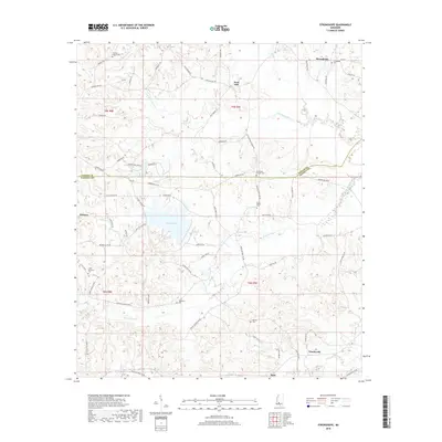
2018 Map of Stronghope
USGS Topo · Published 2018About this map
Lake Lincoln serves as a central geographic anchor for this Mississippi landscape, which is defined by the winding drainages of Little Bahala Creek and Fords Creek. The terrain spans the border between Copiah and Lincoln Counties, revealing a rural settlement pattern rooted in small communities like Stronghope, Woolworth, and Sand Hill. For those tracing local genealogy or land use, the map identifies numerous burial sites, including Stronghope Cemetery and Little Bahala Cemetery, often located near crossroads and creek bends. The road network, comprising local routes like Beauregard Road and Mission Hill Road NE, follows the natural contours of the ridges and valleys between Bear Creek and Little Beaverdam Creek, illustrating how the physical topography has historically dictated the movement and development of this southern Mississippi region.
Find a feature on this map
68 named features on this map. Tap any name to fly to it.
Don’t see what you’re looking for? This feature index may not catch every label — zoom into the map to look around manually.
Map Details
Editions of this 2018 Stronghope Map
This is the sole edition of this map. No revisions or reprints were ever made.
Other maps of this area

1953 · Natchez
USGS Topo · 1:250,000

1956 · Natchez
USGS Topo · 1:250,000

1959 · Natchez
USGS Topo · 1:250,000

1963 · Hazlehurst
USGS Topo · 1:24,000

1963 · Shady Grove
USGS Topo · 1:24,000

1970 · Nola
USGS Topo · 1:24,000

1971 · Oma
USGS Topo · 1:24,000
1971 · Georgetown
USGS Topo · 1:24,000

1972 · Fair Oak Springs
USGS Topo · 1:24,000
1972 · Stronghope
USGS Topo · 1:24,000