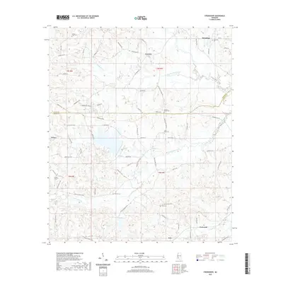
2020 Map of Stronghope
USGS Topo · Published 2020About this map
Stronghope and Woolworth anchor this rural landscape along the boundary of Copiah and Lincoln counties. The terrain is defined by the branching drainages of Bahala Creek and its smaller tributaries, including Little Bahala Creek and Fords Cr, which carve through the wooded hillsides. This area is heavily dotted with family and community burial sites, indicating a long-standing settlement pattern tied to the land. From the Little Memorial Cem in the west to the Stronghope Cem in the northeast, these landmarks serve as vital points for genealogical research. The network of local roads, such as Beauregard Rd and Timberlane Rd, connects dispersed residences and small settlements like Sand Hill and Rafn. The density of named cemeteries, including Thompson Chapel Cem and Warren Cem, suggests a deeply rooted community structure that persists even as the larger centers of commerce remain beyond the immediate horizon.
Find a feature on this map
76 named features on this map. Tap any name to fly to it.
Don’t see what you’re looking for? This feature index may not catch every label — zoom into the map to look around manually.
Map Details
Editions of this 2020 Stronghope Map
This is the sole edition of this map. No revisions or reprints were ever made.
Other maps of this area

1953 · Natchez
USGS Topo · 1:250,000

1956 · Natchez
USGS Topo · 1:250,000

1959 · Natchez
USGS Topo · 1:250,000

1963 · Hazlehurst
USGS Topo · 1:24,000

1963 · Shady Grove
USGS Topo · 1:24,000

1970 · Nola
USGS Topo · 1:24,000

1971 · Oma
USGS Topo · 1:24,000
1971 · Georgetown
USGS Topo · 1:24,000

1972 · Fair Oak Springs
USGS Topo · 1:24,000
1972 · Stronghope
USGS Topo · 1:24,000