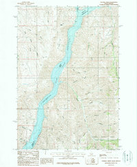
1987 Map of Sturgill Creek
USGS Topo · Published 1987About this map
Snake River canyon walls define this rugged borderland between Idaho and Oregon, dominated by the expansive Brownlee Reservoir as it appeared in the late 1980s. The terrain east of the water rises sharply into the Payette National Forest, where high ridges are dissected by drainage systems like Sturgill Gulch, Garden Gulch, and Limestone Gulch. On the Oregon side, the landscape is marked by unique topological features including Coyote Flat and the confluence of the Powder River. The map provides a detailed view of the drainage patterns and spring locations, such as Andrew Spring, which were critical for livestock and land management in this remote high-desert environment. The network of gulches and creeks, including Quicksand Creek and Lick Creek, illustrates the complex erosion patterns and natural pathways through the canyon country.
Find a feature on this map
27 named features on this map. Tap any name to fly to it.
Don’t see what you’re looking for? This feature index may not catch every label — zoom into the map to look around manually.
Map Details
Editions of this 1987 Sturgill Creek Map
This is the sole edition of this map. No revisions or reprints were ever made.
Other maps of this area

1915 · Pine
USGS Topo · 1:125,000

1955 · Baker
USGS Topo · 1:250,000

1957 · Halfway
USGS Topo · 1:62,500

1957 · Copperfield
USGS Topo · 1:62,500

1957 · Sturgill Peak
USGS Topo · 1:62,500

1957 · Mineral
USGS Topo · 1:62,500

1959 · Baker
USGS Topo · 1:250,000

1980 · McCall
USGS Topo · 1:100,000

1981 · Baker
USGS Topo · 1:100,000
1987 · Brownlee Dam
USGS Topo · 1:24,000