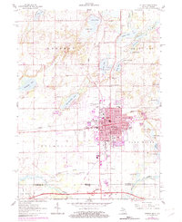
1961 Map of Sturgis
USGS Topo · Published 1982About this map
Sturgis serves as the industrial and social hub of this borderland region, where the Conrail rail line intersects a dense network of city streets like Chicago Rd and Lafayette St. The map captures a transition era for the city, showing the expansion of the Kirsch Municipal Airport and a centralized educational system featuring the Jr High Sch, Wenzel St Sch, and Jerolene St Sch. Just south of the municipal limits, the Michigan Indiana border is clearly defined, with the Indiana Toll Road and the Howe-Lagrange Tollgate marking the gateway into the neighboring state. The surrounding landscape in Sherman and Burr Oak townships is defined by glacial kettle lakes, including Minnewaukan Lake, Perrin Lake, and Thompson Lake, providing a clear record of the area's hydrology before later development. Local heritage is preserved through landmarks like Oak Lawn Cemetery, Tobey Cem, and the Lighthouse Ch.
Find a feature on this map
72 named features on this map. Tap any name to fly to it.
Don’t see what you’re looking for? This feature index may not catch every label — zoom into the map to look around manually.
Map Details
Editions of this 1961 Sturgis Map
2 editions found
Other maps of this area

1914 · Three Rivers
USGS Topo · 1:62,500

1916 · Three Rivers
USGS Topo · 1:62,500

1943 · Three Rivers
USGS Topo · 1:62,500

1947 · Mongo
USGS Topo · 1:24,000

1947 · Lagrange
USGS Topo · 1:24,000

1953 · Fort Wayne
USGS Topo · 1:250,000

1956 · Fort Wayne
USGS Topo · 1:250,000
1960 · Lagrange
USGS Topo · 1:24,000
1960 · Mongo
USGS Topo · 1:24,000
1961 · Sturgis
USGS Topo · 1:24,000