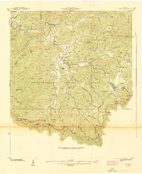
1938 Map of Suches
USGS Topo · Published 1938About this map
Suches and the surrounding high mountain gaps of Union County appear in this 1938 survey, conducted as the Chattahoochee National Forest consolidated its footprint. The terrain is defined by the sharp elevations of Ball Mountain and Rich Mountain, with the Toccoa River winding through the northern valley. Settlement is clustered in small pockets like Gaddistown and Baxter, where community life centered on landmarks like the Peggy Hale Sch and Mt Pleasant Ch. A notable feature of this New Deal-era landscape is the CCC Camp F1 near Woody Lake, marking the federal government's active role in mountain land management. Genealogy researchers will find several family-named landmarks and rural institutions, including the Mt Lebanon Sch and Spriggs Cem, along with a segment of the Appalachian Trail following the Blue Ridge divide.
Find a feature on this map
99 named features on this map. Tap any name to fly to it.
Don’t see what you’re looking for? This feature index may not catch every label — zoom into the map to look around manually.
Map Details
Editions of this 1938 Suches Map
This is the sole edition of this map. No revisions or reprints were ever made.
Other maps of this area

1886 · Dahlonega
USGS Topo · 1:125,000

1888 · Ellijay
USGS Topo · 1:125,000

1892 · Dahlonega
USGS Topo · 1:125,000

1892 · Ellijay
USGS Topo · 1:125,000

1896 · Dahlonega
USGS Topo · 1:125,000

1898 · Ellijay
USGS Topo · 1:125,000

1903 · Dahlonega
USGS Topo · 1:125,000

1911 · Ellijay
USGS Topo · 1:125,000

1935 · Coosa Bald
USGS Topo · 1:24,000

1935 · Mulky Gap
USGS Topo · 1:24,000