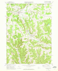
1968 Map of Sugar Grove
USGS Topo · Published 1972About this map
The borderlands of New York and Pennsylvania define this landscape, where the rural settlements of Sugar Grove and Chandlers Valley serve as centers for a community shaped by stream valleys and upland ridges. The mapping reveals a distinct pattern of small country churches and cemeteries, such as Peoples Ch and Cherry Hill Cem, which anchor the local history of the Sugar Grove and Farmington townships.
Find a feature on this map
41 named features on this map. Tap any name to fly to it.
Don’t see what you’re looking for? This feature index may not catch every label — zoom into the map to look around manually.
Map Details
Editions of this 1968 Sugar Grove Map
3 editions found
Other maps of this area

1904 · Chautaqua
USGS Topo · 1:62,500

1905 · Jamestown
USGS Topo · 1:62,500

1906 · Warren
USGS Topo · 1:62,500

1907 · Warren
USGS Topo · 1:62,500

1908 · Warren
USGS Topo · 1:62,500

1926 · Youngsville
USGS Topo · 1:62,500

1929 · Youngsville
USGS Topo · 1:62,500

1941 · Chautauqua
USGS Topo · 1:62,500

1942 · Jamestown
USGS Topo · 1:62,500

1943 · Youngsville
USGS Topo · 1:62,500