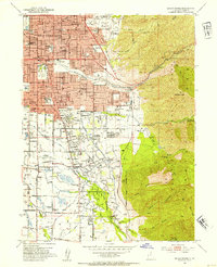
1952 Map of Sugar House
USGS Topo · Published 1954About this map
Sugar House serves as a primary hub on this mid-century portrait of southeastern Salt Lake City, showing the transition from urban density to the foothills of the Wasatch Range. The landscape is notably marked by institutional and educational development, featuring Westminster College, St. Mary of the Wasatch, and an abandoned State Prison site near Rosslyn Heights. To the south, the community of Holladay and the intersection at Knudsens Corner illustrate the residential expansion pushing toward the mountains.
Find a feature on this map
80 named features on this map. Tap any name to fly to it.
Don’t see what you’re looking for? This feature index may not catch every label — zoom into the map to look around manually.
Map Details
Editions of this 1952 Sugar House Map
2 editions found
Other maps of this area

1885 · Salt Lake
USGS Topo · 1:250,000

1925 · Ft. Douglas
USGS Topo · 1:125,000

1928 · Ft. Douglas
USGS Topo · 1:125,000

1950 · Fort Douglas
USGS Topo · 1:24,000

1951 · Fort Douglas
USGS Topo · 1:24,000

1951 · Salt Lake City South
USGS Topo · 1:24,000

1951 · Midvale
USGS Topo · 1:24,000

1951 · Salt Lake City North
USGS Topo · 1:24,000

1952 · Sugar House
USGS Topo · 1:24,000
1952 · Draper
USGS Topo · 1:24,000