
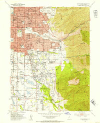
1952 Map of Sugar House
USGS Topo · Published 1954About this map
Salt Lake City spreads eastward toward the steep slopes of the Wasatch National Forest in this mid-century survey, capturing the suburban development of Sugar House and Rosslyn Heights. The urban landscape transitions from dense residential blocks and industrial markers like the Brick Kilns to the open recreational spaces of the Country Club and Bonneville Golf Course. A notable landmark of the era is the State Prison (Abandoned) south of Parleys Creek, situated just before the terrain rises into the deep canyons of the Wasatch Range.
Find a feature on this map
81 named features on this map. Tap any name to fly to it.
Don’t see what you’re looking for? This feature index may not catch every label — zoom into the map to look around manually.
Map Details
Editions of this 1952 Sugar House Map
2 editions found
Other maps of this area

1885 · Salt Lake
USGS Topo · 1:250,000

1925 · Ft. Douglas
USGS Topo · 1:125,000

1928 · Ft. Douglas
USGS Topo · 1:125,000

1950 · Fort Douglas
USGS Topo · 1:24,000

1951 · Fort Douglas
USGS Topo · 1:24,000

1951 · Salt Lake City South
USGS Topo · 1:24,000

1951 · Midvale
USGS Topo · 1:24,000

1951 · Salt Lake City North
USGS Topo · 1:24,000
1952 · Draper
USGS Topo · 1:24,000

1954 · Salt Lake City
USGS Topo · 1:250,000