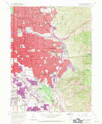
1963 Map of Sugar House
USGS Topo · Published 1971About this map
Salt Lake City and its southeastern reaches undergo significant urban transformation in this mid-century record, where residential expansion pushes right against the steep slopes of the Wasatch National Forest. The transition from historic landmarks like Liberty Park and Westminster College to the burgeoning commercial hubs at Foothill Village and the Cottonwood Mall Shopping Center reflects the post-war growth of the region. Local infrastructure is defined by a complex irrigation and water network, including the Salt Lake City Canal and the Wasatch Aqueduct, which support the landscape between the industrialized Brick Kilns and the serene Wasatch Lawn Memorial Park. In the foothills, institutional developments like St Mary of the Wasatch Sch and Highland High Sch stand as anchors for the developing neighborhoods of Sugar House, East Millcreek, and Holladay.
Find a feature on this map
136 named features on this map. Tap any name to fly to it.
Don’t see what you’re looking for? This feature index may not catch every label — zoom into the map to look around manually.
Map Details
Editions of this 1963 Sugar House Map
3 editions found

Other maps of this area

1885 · Salt Lake
USGS Topo · 1:250,000

1925 · Ft. Douglas
USGS Topo · 1:125,000

1928 · Ft. Douglas
USGS Topo · 1:125,000

1950 · Fort Douglas
USGS Topo · 1:24,000

1951 · Fort Douglas
USGS Topo · 1:24,000

1951 · Salt Lake City South
USGS Topo · 1:24,000
1951 · Midvale
USGS Topo · 1:24,000

1951 · Salt Lake City North
USGS Topo · 1:24,000

1952 · Sugar House
USGS Topo · 1:24,000
1952 · Draper
USGS Topo · 1:24,000