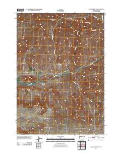
2011 Map of Sugarloaf Butte
USGS Topo · Published 2011About this map
Sugarloaf Butte and Houston Butte rise above the high desert floor in this 2011 U.S. Geological Survey representation of central Oregon. The landscape is defined by a dendritic network of intermittent drainage, where seasonal flows like Spring Creek, Cow Creek, and Ant Creek have carved deep recesses into the plateau. These geological processes are most evident in the formation of Juniper Canyon and Norman Canyon in the southwest. A sparse network of rural routes, including Roberts Rd and SE Bear Creek Rd, provides the primary access through this rangeland. The presence of named landmarks such as Millihorn Hill and South Fork Hill suggests the importance of these high points for local navigation and livestock management in a region where water sources like Bear Creek are vital but scattered.
Find a feature on this map
14 named features on this map. Tap any name to fly to it.
Don’t see what you’re looking for? This feature index may not catch every label — zoom into the map to look around manually.
Map Details
Editions of this 2011 Sugarloaf Butte Map
This is the sole edition of this map. No revisions or reprints were ever made.
Other maps of this area

1946 · Eagle Rock
USGS Topo · 1:62,500

1948 · Eagle Rock
USGS Topo · 1:62,500

1951 · Post
USGS Topo · 1:62,500

1955 · Crescent
USGS Topo · 1:250,000

1955 · Bend
USGS Topo · 1:250,000

1957 · Crescent
USGS Topo · 1:250,000

1957 · Bend
USGS Topo · 1:250,000

1958 · Crescent
USGS Topo · 1:250,000

1958 · Bend
USGS Topo · 1:250,000

1967 · Brothers NW
USGS Topo · 1:24,000