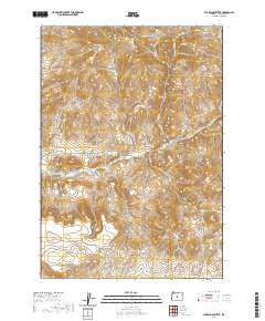
2020 Map of Sugarloaf Butte
USGS Topo · Published 2020About this map
Sugarloaf Butte and the surrounding high desert terrain of Crook County define this landscape as it was documented in the late 2010s. The area is characterized by a series of prominent rises and deep drainage cuts, including Millihorn Hill, Houston Butte, and the striking Rodman Rim to the southwest. These geological features influence the path of local infrastructure, such as Roberts Rd and Bear Creek-Fife Rd, which navigate the elevation changes between the peaks and canyons.
Find a feature on this map
16 named features on this map. Tap any name to fly to it.
Don’t see what you’re looking for? This feature index may not catch every label — zoom into the map to look around manually.
Map Details
Editions of this 2020 Sugarloaf Butte Map
This is the sole edition of this map. No revisions or reprints were ever made.
Other maps of this area

1946 · Eagle Rock
USGS Topo · 1:62,500

1948 · Eagle Rock
USGS Topo · 1:62,500

1951 · Post
USGS Topo · 1:62,500

1955 · Crescent
USGS Topo · 1:250,000

1955 · Bend
USGS Topo · 1:250,000

1957 · Crescent
USGS Topo · 1:250,000

1957 · Bend
USGS Topo · 1:250,000

1958 · Crescent
USGS Topo · 1:250,000

1958 · Bend
USGS Topo · 1:250,000

1967 · Brothers NW
USGS Topo · 1:24,000