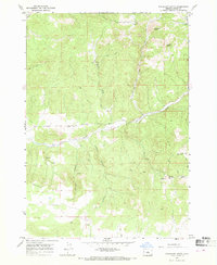
1967 Map of Sugarloaf Butte
USGS Topo · Published 1968About this map
Sugarloaf Butte and the dramatic escarpment of Rodman Rim define this high-desert landscape in Crook County during the late 1960s. The terrain is deeply incised by drainages like Bear Creek, Ant Creek, and the parallel cuts of Juniper Canyon and Norman Canyon. This quadrangle illustrates a landscape primarily shaped by natural topography and water access, with several Springs and Wells serving as vital nodes in an otherwise arid environment. Human activity is evidenced by a network of Jeep Trails and occasional infrastructure such as a Drill Hole in the southern sector. The map provides a clear look at the area's prominent volcanic landforms, including Houston Butte and South Fork Hill, before modern development or intensive land use altered the character of this part of Central Oregon.
Find a feature on this map
14 named features on this map. Tap any name to fly to it.
Don’t see what you’re looking for? This feature index may not catch every label — zoom into the map to look around manually.
Map Details
Editions of this 1967 Sugarloaf Butte Map
This is the sole edition of this map. No revisions or reprints were ever made.
Other maps of this area

1946 · Eagle Rock
USGS Topo · 1:62,500

1948 · Eagle Rock
USGS Topo · 1:62,500

1951 · Post
USGS Topo · 1:62,500

1955 · Crescent
USGS Topo · 1:250,000

1955 · Bend
USGS Topo · 1:250,000

1957 · Crescent
USGS Topo · 1:250,000

1957 · Bend
USGS Topo · 1:250,000

1958 · Crescent
USGS Topo · 1:250,000

1958 · Bend
USGS Topo · 1:250,000

1967 · Brothers NW
USGS Topo · 1:24,000