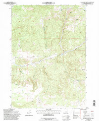
1992 Map of Sugarloaf Butte
USGS Topo · Published 1997About this map
Sugarloaf Butte and Houston Butte rise above a landscape of high desert drainage and volcanic formations in this Crook County region. The terrain is defined by deep incisions like Jumper Canyon and Norman Canyon that draw down toward Bear Creek, which meanders across the central portion of the quadrangle. A significant geological feature, the Rodman Rim, creates a sharp topographic break in the southwest, indicative of the rimrock country common to this part of Oregon. While largely an unpopulated area within the National Forest system, the map indicates localized resource exploration or agricultural development through the presence of a Drill Hole and several scattered Wells. These markers, along with various named Springs, show the critical importance of water management and subsurface access in the high plateau environment of the early 1990s.
Find a feature on this map
13 named features on this map. Tap any name to fly to it.
Don’t see what you’re looking for? This feature index may not catch every label — zoom into the map to look around manually.
Map Details
Editions of this 1992 Sugarloaf Butte Map
This is the sole edition of this map. No revisions or reprints were ever made.
Other maps of this area

1946 · Eagle Rock
USGS Topo · 1:62,500

1948 · Eagle Rock
USGS Topo · 1:62,500

1951 · Post
USGS Topo · 1:62,500

1955 · Crescent
USGS Topo · 1:250,000

1955 · Bend
USGS Topo · 1:250,000

1957 · Crescent
USGS Topo · 1:250,000

1957 · Bend
USGS Topo · 1:250,000

1958 · Crescent
USGS Topo · 1:250,000

1958 · Bend
USGS Topo · 1:250,000

1967 · Brothers NW
USGS Topo · 1:24,000