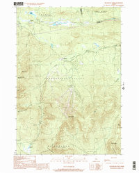
1997 Map of Sugarloaf Mtn
USGS Topo · Published 2000About this map
Sugarloaf Mtn dominates this late-twentieth-century landscape, serving as a focal point for the developing recreational and natural resource infrastructure of the region. The map captures the significant presence of the Appalachian National Scenic Trail as it traverses the high ridges, passing over Crocker Mtn and South Crocker Mtn. This era shows the established community of Carrabassett Valley and the smaller settlement at Stratton, reflecting a shift toward seasonal tourism and outdoor recreation alongside traditional land uses, indicated by several Gravel Pits and a large Transmission Line.
Find a feature on this map
31 named features on this map. Tap any name to fly to it.
Don’t see what you’re looking for? This feature index may not catch every label — zoom into the map to look around manually.
Map Details
Editions of this 1997 Sugarloaf Mtn Map
This is the sole edition of this map. No revisions or reprints were ever made.
Other maps of this area

1928 · Dead River
USGS Topo · 1:62,500

1928 · Stratton
USGS Topo · 1:48,000

1929 · Phillips
USGS Topo · 1:48,000

1930 · Kingfield
USGS Topo · 1:48,000

1931 · Dead River
USGS Topo · 1:48,000

1932 · Phillips
USGS Topo · 1:62,500

1932 · Stratton
USGS Topo · 1:62,500

1932 · Kingfield
USGS Topo · 1:62,500

1944 · Dead River
USGS Topo · 1:62,500

1949 · Jackman
USGS Topo · 1:250,000
Featured Places
- Kingfield, ME
- Carrabassett Valley, ME
- Wyman Township, ME
- Dead River Township, ME
- Mount Abram Township, ME