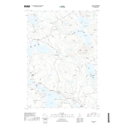
2018 Map of Sullivan
USGS Topo · Published 2018About this map
Sullivan and its neighboring coastal villages of West Sullivan, North Sullivan, and East Sullivan sit along the jagged edge of the Sullivan Harbor and Hog Bay. This survey captures the intricate shoreline of Frenchman Bay, where the Hancock-Sullivan Bridge spans the tidal waters. The interior landscape is defined by granite peaks and dense marshlands, including Schoodic Mtn and Fiery Mtn, alongside the complex drainage of Schoodic Bog and Dry Heath. Genealogists will find a high density of small family and community burial grounds throughout the area, such as York Hill Cem, Salter Cem, and Blaisdell Cem. Further north, the map details the rural character of Franklin and East Franklin, where the terrain transitions toward Donnell Pond and the high ridges of Caribou Mtn. The prevalence of named points like Julius Darling Point and Shipyard Point reflects a long history of maritime activity and coastal settlement.
Find a feature on this map
156 named features on this map. Tap any name to fly to it.
Don’t see what you’re looking for? This feature index may not catch every label — zoom into the map to look around manually.
Map Details
Editions of this 2018 Sullivan Map
This is the sole edition of this map. No revisions or reprints were ever made.
Other maps of this area

1904 · Mount Desert
USGS Topo · 1:62,500

1904 · Bar Harbor
USGS Topo · 1:62,500

1911 · Ellsworth
USGS Topo · 1:62,500

1930 · Tunk Lake
USGS Topo · 1:48,000

1932 · Tunk Lake
USGS Topo · 1:62,500

1940 · Ellsworth
USGS Topo · 1:62,500

1942 · Bar Harbor
USGS Topo · 1:62,500

1942 · Ellsworth
USGS Topo · 1:62,500

1942 · Mount Desert
USGS Topo · 1:62,500

1942 · Tunk Lake
USGS Topo · 1:62,500