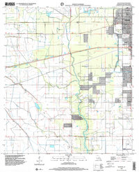
1998 Map of Sulphur
USGS Topo · Published 2000About this map
Sulphur sits at the northern edge of this landscape, where the transition from industrial activity to coastal prairie is marked by a complex network of man-made and natural waterways. The presence of Brimstone and various oil extraction sites speaks to the region's long-standing reliance on mineral wealth, while the residential expansion toward Carlyss and the presence of Frasch Park indicate a maturing community. The terrain is defined by its drainage patterns, with Choupique Bayou, Spring Gully, and the Drew Canal cutting through the low-lying plains. Significant infrastructure includes the Sabine Canal and extensive levee systems designed to manage water across this flat coastal interior. For local history, the Roseland Cem and the small settlement at Stegall provide specific points of reference for tracing family lineages and early development patterns in Calcasieu Parish.
Find a feature on this map
42 named features on this map. Tap any name to fly to it.
Don’t see what you’re looking for? This feature index may not catch every label — zoom into the map to look around manually.
Map Details
Editions of this 1998 Sulphur Map
This is the sole edition of this map. No revisions or reprints were ever made.
Other maps of this area

1932 · Moss Lake
USGS Topo · 1:31,680

1932 · Orange
USGS Topo · 1:62,500

1935 · Buhler
USGS Topo · 1:31,680

1946 · Moss Lake
USGS Topo · 1:31,680

1947 · Sulphur
USGS Topo · 1:31,680

1947 · Vinton
USGS Topo · 1:31,680

1947 · Sulphur Mines
USGS Topo · 1:31,680
1947 · West Lake
USGS Topo · 1:31,680

1947 · Lunita
USGS Topo · 1:31,680
1949 · Cameron Farms
USGS Topo · 1:31,680