
1947 Map of Sulphur Mines
USGS Topo · Published 1947About this map
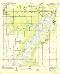
Sulphur Mines serves as a focal point for this landscape in Calcasieu Parish, where industrial extraction and water management dominate the terrain. The 1930s field examination reveals an intricate network of man-made waterways, including the Irrigation Canal and the Union Sulphur Canal (Abandoned), which crisscross the low-lying areas near the Houston River. These canals and drainage ditches underscore the heavy modification of the wetlands for both agriculture and industry during this era.
Find a feature on this map
19 named features on this map. Tap any name to fly to it.
Don’t see what you’re looking for? This feature index may not catch every label — zoom into the map to look around manually.
Map Details
Editions of this 1947 Sulphur Mines Map
This is the sole edition of this map. No revisions or reprints were ever made.
Other maps of this area

1932 · Orange
USGS Topo · 1:62,500

1935 · Buhler
USGS Topo · 1:31,680

1935 · Gordon
USGS Topo · 1:31,680

1947 · Sulphur
USGS Topo · 1:31,680

1947 · Vinton
USGS Topo · 1:31,680

1947 · DeQuincy
USGS Topo · 1:31,680
1947 · West Lake
USGS Topo · 1:31,680

1947 · Lunita
USGS Topo · 1:31,680

1947 · Long Marsh
USGS Topo · 1:31,680

1952 · Lake Charles
USGS Topo · 1:250,000