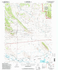
1994 Map of Sulphur Mountain
USGS Topo · Published 1998About this map
Sulphur Mountain and the high-altitude ranching landscape of Park County are captured here in a 1990s survey, showing the complex water-management systems required for this arid terrain. The South Platte River and its Middle Fork feed into the Spinney Mountain Reservoir, supported by an intricate network of irrigation channels including the Harrington Ditch, Fritts Ditch, and Western Ditch. Residential development is concentrated at Pike-San Isabel Village, while the surrounding land remains largely dedicated to large agricultural holdings such as Buckley Ranch, Spinney Ranch, and Harrington Ranch. The northern reaches include portions of the Pike National Forest and various geological markers like Chalcedony Spring and an isolated Oil Well. Significant land use designations like the Spinney Mountain Wildlife Area highlight the region's shift toward conservation and public recreation at the end of the 20th century.
Find a feature on this map
36 named features on this map. Tap any name to fly to it.
Don’t see what you’re looking for? This feature index may not catch every label — zoom into the map to look around manually.
Map Details
Editions of this 1994 Sulphur Mountain Map
This is the sole edition of this map. No revisions or reprints were ever made.
Other maps of this area

1953 · Denver
USGS Topo · 1:250,000

1954 · Pueblo
USGS Topo · 1:250,000

1956 · Eagle Rock
USGS Topo · 1:24,000

1956 · Elkhorn
USGS Topo · 1:24,000

1956 · Sulphur Mountain
USGS Topo · 1:24,000

1956 · Farnum Peak
USGS Topo · 1:24,000

1956 · Antero Reservoir NE
USGS Topo · 1:24,000

1956 · Hartsel
USGS Topo · 1:24,000

1956 · Guffey NW
USGS Topo · 1:24,000

1956 · Glentivar
USGS Topo · 1:24,000