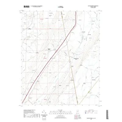
2020 Map of Sulphur Springs
USGS Topo · Published 2020About this map
Battelle and Sulphur Springs anchor this portion of the Wills Valley, where the Georgia Alabama border cuts across the high ridges of Sand Mountain and Lookout Mountain. This landscape is defined by its dramatic relief and spring-fed drainage, featuring named coves and gaps like Deer Head Cove and Sulphur Springs Gap. The settlement pattern follows the valley floors and the Railroad Valley, where communities like Gann Crossroad and Sulphur Springs Station developed along the transport corridors. For the family historian, the map preserves the locations of numerous family-named landmarks including Pannell Cem, Bean Cem, and Miller Cem. The presence of Kaolin in the southern section suggests the area's geological and industrial connections to clay mining, while Amos Mill to the east points to the localized water-powered industries that once served these rural DeKalb County communities.
Find a feature on this map
113 named features on this map. Tap any name to fly to it.
Don’t see what you’re looking for? This feature index may not catch every label — zoom into the map to look around manually.
Map Details
Editions of this 2020 Sulphur Springs Map
This is the sole edition of this map. No revisions or reprints were ever made.
Other maps of this area

1886 · Ringgold
USGS Topo · 1:125,000

1886 · Stevenson
USGS Topo · 1:125,000

1892 · Ringgold
USGS Topo · 1:125,000

1892 · Stevenson
USGS Topo · 1:125,000

1895 · Stevenson
USGS Topo · 1:125,000

1935 · Durham
USGS Topo · 1:24,000

1936 · Trenton
USGS Topo · 1:24,000

1936 · Ider
USGS Topo · 1:24,000

1936 · Flat Rock
USGS Topo · 1:24,000

1936 · Dugout Valley
USGS Topo · 1:24,000