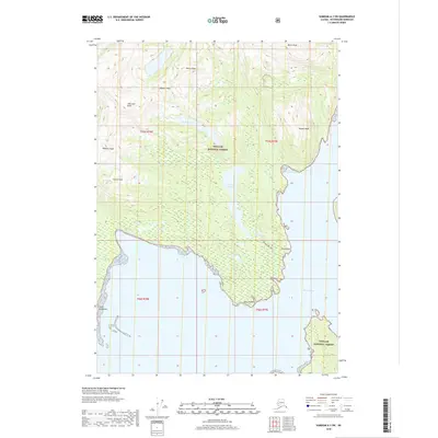
2018 Map of Sumdum A-3 SW
USGS Topo · Published 2018About this map
The Tongass National Forest dominates this coastal Alaska landscape, where high mountain ridges meet the waters of the Frederick Sound. The terrain is defined by a series of prominent summits including Jefferson Peak, Rodman Peak, Hancock Peak, and Powell Peak, which rise sharply above the forested slopes. Along the intricate shoreline, Point Vandeput marks a significant peninsula projecting into the sound, while Spurt Point and Wind Point define the entrance to the deeper waters of Thomas Bay. Inland, the map reveals a system of freshwater bodies and connectivity, featuring De Boer Lake and Spurt Point Lake. The latter is accessible via the Spurt Lake Trail, illustrating the limited but critical human access points within this maritime wilderness. This survey details a transition from alpine peaks to sheltered marine environments like Porter Cove, reflecting the geological and ecological complexity of the Petersburg Borough coastline.
Find a feature on this map
20 named features on this map. Tap any name to fly to it.
Don’t see what you’re looking for? This feature index may not catch every label — zoom into the map to look around manually.
Map Details
Editions of this 2018 Sumdum A-3 SW Map
This is the sole edition of this map. No revisions or reprints were ever made.
Other maps of this area

1948 · Sumdum A-4
USGS Topo · 1:63,360

1951 · Petersburg D-4
USGS Topo · 1:63,360

1951 · Sumdum A-4
USGS Topo · 1:63,360

1952 · Petersburg
USGS Topo · 1:250,000

1952 · Sumdum
USGS Topo · 1:250,000

1960 · Petersburg
USGS Topo · 1:250,000

1961 · Petersburg D-3
USGS Topo · 1:63,360

1961 · Sumdum A-3
USGS Topo · 1:63,360

1961 · Sumdum
USGS Topo · 1:250,000
1995 · Petersburg D-3
USGS Topo · 1:63,360