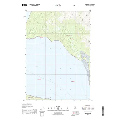
2017 Map of Sumdum A-4 SE
USGS Topo · Published 2017About this map
Tongass National Forest dominates the terrestrial landscape of this coastal survey, where steep terrain rises sharply from the waters of Frederick Sound. The shoreline of Petersburg Borough is marked by a dramatic transition from maritime environments to high elevations, punctuated by prominent summits. In the northern reaches, Hamilton Peak stands as a significant landmark, while Hancock Peak anchors the terrain further south along the coast. This mapping captures the intricate relationship between the coastal shelf and the massive National Forest system in Southeast Alaska. The map provides a clear look at the Public Land Survey System grid, including township markers such as t55s r77e and t55s r78e, which serve as primary reference points for researchers and land managers navigating this wilderness region.
Find a feature on this map
8 named features on this map. Tap any name to fly to it.
Don’t see what you’re looking for? This feature index may not catch every label — zoom into the map to look around manually.
Map Details
Editions of this 2017 Sumdum A-4 SE Map
This is the sole edition of this map. No revisions or reprints were ever made.
Other maps of this area

1948 · Sumdum A-4
USGS Topo · 1:63,360

1951 · Petersburg D-4
USGS Topo · 1:63,360

1951 · Sumdum A-4
USGS Topo · 1:63,360

1952 · Petersburg
USGS Topo · 1:250,000

1952 · Sumdum
USGS Topo · 1:250,000

1960 · Petersburg
USGS Topo · 1:250,000

1961 · Petersburg D-3
USGS Topo · 1:63,360

1961 · Sumdum A-3
USGS Topo · 1:63,360

1961 · Sumdum
USGS Topo · 1:250,000
1995 · Petersburg D-3
USGS Topo · 1:63,360