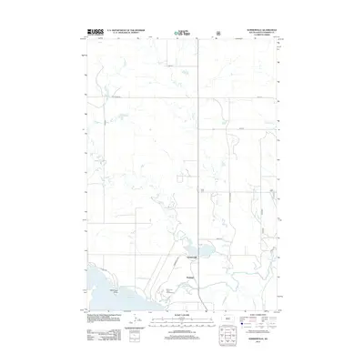
2012 Map of Summerville
USGS Topo · Published 2012About this map
Summerville and Shadehill occupy the southern portion of this Perkins County landscape, situated where the high plains meet the water. The drainage of Flat Cr and its eastern branch, E Flat Cr, define the central topography, flowing south toward Flat Creek Lake and the significant expanse of the Shadehill Reservoir. This reservoir was created by damming the Grand River, which transitions from a riverine system into a large body of water near Ketterlings Point. The area's recreational geography is anchored by the Merrimans Grove Campground, while a strict grid of section-line roads, such as 106th St and 189th Ave, reveals the systematic agricultural layout of the Dakotas. The intersection of Summerville Rd and Dewitt Rd marks the local activity center in an otherwise open prairie environment.
Find a feature on this map
19 named features on this map. Tap any name to fly to it.
Don’t see what you’re looking for? This feature index may not catch every label — zoom into the map to look around manually.
Map Details
Editions of this 2012 Summerville Map
This is the sole edition of this map. No revisions or reprints were ever made.
Other maps of this area

1954 · Lemmon
USGS Topo · 1:250,000

1957 · Lemmon
USGS Topo · 1:250,000

1974 · White Butte
USGS Topo · 1:24,000

1974 · Lemmon
USGS Topo · 1:24,000
1974 · Lemmon NE
USGS Topo · 1:24,000

1983 · Haynes SE
USGS Topo · 1:24,000
1983 · Lemmon Lake
USGS Topo · 1:24,000

1983 · Bison NE
USGS Topo · 1:24,000

1983 · Meadow NW
USGS Topo · 1:24,000
1983 · Meadow NE
USGS Topo · 1:24,000