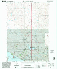
1998 Map of Summerville
USGS Topo · Published 2001About this map
Grand River National Grassland dominates this Northern Plains landscape in Perkins County, where the convergence of the Grand River and Flat Creek creates a vital riparian network. The late 20th-century topography reveals a region defined by large-scale ranching and water management, anchored by the expansive Shadehill Reservoir and the smaller Flat Creek Lake. Several established homesteads, including the E Erlenbusch Ranch, Ham Ranch, and G J Cain Ranch, are scattered across the terrain, reflecting the long-standing ranching tradition of the area. Public access and recreation are central to the local geography at the Llewellyn Johns Memorial State Recreation Area and Shadehill State Recreation Area, which provide infrastructure like the Llewellyn Johns Campground and a boat ramp at Ketterlings Point. The small settlement of Summerville and the nearby Shadehill community serve as focal points for this cattle-country environment.
Find a feature on this map
30 named features on this map. Tap any name to fly to it.
Don’t see what you’re looking for? This feature index may not catch every label — zoom into the map to look around manually.
Map Details
Editions of this 1998 Summerville Map
This is the sole edition of this map. No revisions or reprints were ever made.
Other maps of this area

1954 · Lemmon
USGS Topo · 1:250,000

1957 · Lemmon
USGS Topo · 1:250,000

1974 · White Butte
USGS Topo · 1:24,000

1974 · Lemmon
USGS Topo · 1:24,000
1974 · Lemmon NE
USGS Topo · 1:24,000

1983 · Haynes SE
USGS Topo · 1:24,000
1983 · Lemmon Lake
USGS Topo · 1:24,000

1983 · Bison NE
USGS Topo · 1:24,000

1983 · Meadow NW
USGS Topo · 1:24,000
1983 · Meadow NE
USGS Topo · 1:24,000