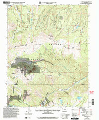
2001 Map of Summitville
USGS Topo · Published 2005About this map
Summitville stands at the center of this high-elevation terrain, illustrating the significant industrial footprint of mining within the Rio Grande National Forest. The landscape is heavily marked by subsurface exploration, with the Chandler Tunnel, French Tunnel, and Iowa Tunnel concentrated near the settlement. These subterranean features, alongside numerous labeled prospects, reflect a history of extracting resources from the peaks of South Mountain and Cropsy Mountain.
Find a feature on this map
49 named features on this map. Tap any name to fly to it.
Don’t see what you’re looking for? This feature index may not catch every label — zoom into the map to look around manually.
Map Details
Editions of this 2001 Summitville Map
This is the sole edition of this map. No revisions or reprints were ever made.
Other maps of this area

1913 · Summitville
USGS Topo · 1:125,000

1914 · Creede
USGS Topo · 1:125,000

1915 · Summitville
USGS Topo · 1:125,000

1915 · Del Norte
USGS Topo · 1:125,000

1916 · Creede
USGS Topo · 1:125,000

1917 · Del Norte
USGS Topo · 1:125,000

1922 · Conejos
USGS Topo · 1:125,000

1945 · Durango
USGS Topo · 1:250,000

1953 · Durango
USGS Topo · 1:250,000

1954 · Durango
USGS Topo · 1:250,000