
1905 Map of Sun Prairie
USGS Topo · Published 1959About this map
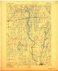
Sun Prairie serves as a primary rail and social hub in this 1905 survey, illustrating a landscape defined by glacial drumlins and an extensive network of early Wisconsin railroads. The Chicago Milwaukee and St Paul RR and the Chicago and Northwestern lines cut through the terrain, connecting agricultural settlements like Cottage Grove, Deerfield, and Marshall. These transportation corridors were vital for the export of produce from the surrounding farmsteads of Bristol and Medina townships.
Find a feature on this map
41 named features on this map. Tap any name to fly to it.
Don’t see what you’re looking for? This feature index may not catch every label — zoom into the map to look around manually.
Map Details
Editions of this 1905 Sun Prairie Map
This is the sole edition of this map. No revisions or reprints were ever made.
Other maps of this area

1889 · Evansville
USGS Topo · 1:62,500

1890 · Madison
USGS Topo · 1:62,500

1890 · Sun Prairie
USGS Topo · 1:62,500

1890 · Stoughton
USGS Topo · 1:62,500

1891 · Waterloo
USGS Topo · 1:62,500

1891 · Koshkonong
USGS Topo · 1:62,500

1892 · Madison
USGS Topo · 1:62,500
1894 · Waterloo
USGS Topo · 1:62,500

1894 · Evansville
USGS Topo · 1:62,500

1894 · Koshkonong
USGS Topo · 1:62,500