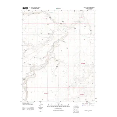
2013 Map of Sun Valley Ranch
USGS Topo · Published 2013About this map
The Apishapa River winds through this high-altitude landscape in Las Animas County, carving a complex network of canyons that define the local geography. Significant elevation changes are marked by features like Berry Point and the Poitrey Arroyo Hills, where the land drops into drainage systems such as Wild Horse Arroyo and the West Fork Long Branch.
Find a feature on this map
35 named features on this map. Tap any name to fly to it.
Don’t see what you’re looking for? This feature index may not catch every label — zoom into the map to look around manually.
Map Details
Editions of this 2013 Sun Valley Ranch Map
This is the sole edition of this map. No revisions or reprints were ever made.
Other maps of this area

1891 · Apishapa
USGS Topo · 1:125,000

1893 · Apishapa
USGS Topo · 1:125,000

1897 · Apishapa
USGS Topo · 1:125,000

1954 · Trinidad
USGS Topo · 1:250,000

1955 · Trinidad
USGS Topo · 1:250,000

1958 · Trinidad
USGS Topo · 1:250,000

1959 · Trinidad
USGS Topo · 1:250,000
1970 · Snowden Lake
USGS Topo · 1:24,000
1970 · Delhi
USGS Topo · 1:24,000
1970 · Thatcher
USGS Topo · 1:24,000