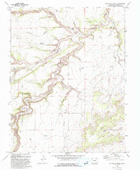
1993 Map of Sun Valley Ranch
USGS Topo · Published 1993About this map
The Apishapa River carves a deep, winding path through the high plains of Las Animas County, creating the dramatic Apishapa Canyon that dominates this landscape. Managed largely as the Apishapa State Wildlife Area, the region is defined by its complex drainage network, where numerous side canyons like Iron Spring Canyon, Bass Canyon, and Orr Canyon feed into the main river corridor. Settlement is sparse and tied directly to water sources, centered on the Sun Valley Ranch and isolated landmarks such as Bruenellie Windmill and Hixson Windmill. This 1993 edition, revised from 1969 aerial photography, captures the intricate topography of the Hills to the southeast, where Poitrey Arroyo and Wild Horse Arroyo emphasize the arid, erosion-sculpted character of southern Colorado.
Find a feature on this map
34 named features on this map. Tap any name to fly to it.
Don’t see what you’re looking for? This feature index may not catch every label — zoom into the map to look around manually.
Map Details
Editions of this 1993 Sun Valley Ranch Map
This is the sole edition of this map. No revisions or reprints were ever made.
Other maps of this area

1891 · Apishapa
USGS Topo · 1:125,000

1893 · Apishapa
USGS Topo · 1:125,000

1897 · Apishapa
USGS Topo · 1:125,000

1954 · Trinidad
USGS Topo · 1:250,000

1955 · Trinidad
USGS Topo · 1:250,000

1958 · Trinidad
USGS Topo · 1:250,000

1959 · Trinidad
USGS Topo · 1:250,000
1970 · Snowden Lake
USGS Topo · 1:24,000
1970 · Delhi
USGS Topo · 1:24,000
1970 · Thatcher
USGS Topo · 1:24,000