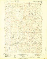
1950 Map of Sundquist Ranch
USGS Topo · Published 1950About this map
Sundquist Ranch serves as the central landmark for this rural portion of Converse County, mapped at the close of the 1940s. The landscape is defined by the drainage systems of Lightning Creek and Fetterman Creek, which provide vital water sources in this arid environment. The map records a nascent industrial presence with a Pipe Line and specific Oil extraction sites, signaling the expansion of energy infrastructure in the post-war West. Agricultural utility is evidenced by a Dam and several Windmill structures scattered across the terrain, which is punctuated by high points named Blue and Tick. The presence of a Corral further emphasizes the area's primary identity as cattle country during the development of the Missouri River Basin.
Find a feature on this map
11 named features on this map. Tap any name to fly to it.
Don’t see what you’re looking for? This feature index may not catch every label — zoom into the map to look around manually.
Map Details
Editions of this 1950 Sundquist Ranch Map
This is the sole edition of this map. No revisions or reprints were ever made.
Other maps of this area

1949 · Sundquist Ranch
USGS Topo · 1:24,000

1949 · Orpha
USGS Topo · 1:24,000

1949 · Gilbert Lake
USGS Topo · 1:24,000

1949 · Douglas
USGS Topo · 1:24,000

1949 · Clausen Ranch
USGS Topo · 1:24,000

1949 · Antelope Creek
USGS Topo · 1:24,000

1950 · Clausen Ranch
USGS Topo · 1:24,000

1950 · Gilbert Lake
USGS Topo · 1:24,000

1950 · Douglas
USGS Topo · 1:24,000

1950 · Orpha
USGS Topo · 1:24,000