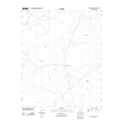
2011 Map of Sunflower Butte
USGS Topo · Published 2011About this map
Sunflower Butte and its surrounding high desert landscape are defined by a complex drainage system and isolated volcanic or sedimentary landforms within Navajo County. The area is characterized by prominent elevations including Sheep Butte, Ram Butte, and the expansive Malpais Mesa, which overlook a network of seasonal watercourses like the Pueblo Colorado Wash and Sunflower Butte Wash.
Find a feature on this map
19 named features on this map. Tap any name to fly to it.
Don’t see what you’re looking for? This feature index may not catch every label — zoom into the map to look around manually.
Map Details
Editions of this 2011 Sunflower Butte Map
This is the sole edition of this map. No revisions or reprints were ever made.
Other maps of this area

1883 · Tusayan
USGS Topo · 1:250,000

1886 · Tusayan
USGS Topo · 1:250,000

1947 · Flagstaff
USGS Topo · 1:250,000

1954 · Flagstaff
USGS Topo · 1:250,000

1958 · Flagstaff
USGS Topo · 1:250,000

1960 · Flagstaff
USGS Topo · 1:250,000

1962 · Flagstaff
USGS Topo · 1:250,000
1967 · Dilkon
USGS Topo · 1:24,000
1967 · French Butte
USGS Topo · 1:24,000
1972 · Turkey Track Butte
USGS Topo · 1:24,000