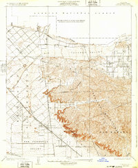
1932 Map of Sunland
USGS Topo · Published 1932About this map
The Verdugo Mountains and San Rafael Hills dominate the southern landscape of this survey, standing as a natural barrier between the expanding San Fernando Valley and the Tujunga Valley to the north. Settlement during this era is concentrated around Sunland, where a grid of streets like Michigan Ave meets the southern edge of the Angeles National Forest. To the southwest, the Southern Pacific railroad parallels San Fernando Road, anchoring small transit points like Roscoe, Wahoo, and Hewitt. The intricate drainage patterns of the Little Tujunga Wash and Tujunga Wash illustrate the historical floodplains that shaped early Los Angeles development, while the Edison Power Line cutting across the foothills marks the region's growing utility infrastructure. This 1930s-era snapshot captures the transition from open washlands to defined city boundaries before mid-century suburbanization filled the valley floor.
Find a feature on this map
28 named features on this map. Tap any name to fly to it.
Don’t see what you’re looking for? This feature index may not catch every label — zoom into the map to look around manually.
Map Details
Editions of this 1932 Sunland Map
This is the sole edition of this map. No revisions or reprints were ever made.
Other maps of this area

1894 · Los Angeles
USGS Topo · 1:62,500

1896 · Santa Monica
USGS Topo · 1:62,500

1898 · Santa Monica
USGS Topo · 1:62,500

1900 · Los Angeles
USGS Topo · 1:62,500

1900 · Fernando
USGS Topo · 1:62,500

1901 · Southern California Sheet No. 1
USGS Topo · 1:250,000

1902 · Santa Monica
USGS Topo · 1:62,500

1904 · Southern California Sheet No. 1
USGS Topo · 1:250,000

1920 · Santa Monica
USGS Topo · 1:62,500
1921 · Santa Monica
USGS Topo · 1:62,500