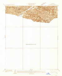
1933 Map of Sunland
USGS Topo · Published 1933About this map
The San Gabriel Mountains dominate this 1933 advance sheet, revealing the early infrastructure of the Angeles National Forest before widespread suburban expansion reached this high into the canyons. Small settlements and specialized outposts like El Merrie Del and the Fernando Ranger Sta are nestled at the mountain base, while Herreras Ranch and Selby Oaks mark the footprint of early residents. The terrain is deeply incised by a series of drainages, including Wildwood Canyon and Gold Canyon, which descend toward the Little Tujunga Canyon floor. The mapping of a high-altitude Firebreak and multiple tanks suggests an era intensely focused on watershed management and fire prevention. Water resources are further highlighted by landmarks such as Dexter Park Reservoir and the uniquely named Fascination Spring, illustrating how essential these mountain sources were for the developing communities below.
Find a feature on this map
21 named features on this map. Tap any name to fly to it.
Don’t see what you’re looking for? This feature index may not catch every label — zoom into the map to look around manually.
Map Details
Editions of this 1933 Sunland Map
This is the sole edition of this map. No revisions or reprints were ever made.
Other maps of this area

1894 · Los Angeles
USGS Topo · 1:62,500

1896 · Santa Monica
USGS Topo · 1:62,500

1898 · Santa Monica
USGS Topo · 1:62,500

1900 · Los Angeles
USGS Topo · 1:62,500

1900 · Fernando
USGS Topo · 1:62,500

1901 · Southern California Sheet No. 1
USGS Topo · 1:250,000

1902 · Santa Monica
USGS Topo · 1:62,500

1904 · Southern California Sheet No. 1
USGS Topo · 1:250,000

1920 · Santa Monica
USGS Topo · 1:62,500
1921 · Santa Monica
USGS Topo · 1:62,500