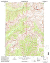
1991 Map of Sunlight Peak
USGS Topo · Published 1997About this map
The North Fork Shoshone River carves through the high terrain of northwest Wyoming, anchoring a landscape dominated by the Shoshone National Forest and the Absaroka Wilderness. Revised by the Forest Service in the early 1990s, this survey highlights the convergence of drainage systems including Grinnell Creek, Sweetwater Creek, and Mormon Creek. High-elevation landmarks like Sunlight Peak and Whirlwind Peak define the horizon, while the Newton Prospect in the Silvertip Basin points to the area's history of mineral exploration. The presence of the Thirteenth Standard Parallel North and the Wapiti Clarks Fork Ranger District Boundary underscores the administrative and surveying framework used to manage these remote mountain stretches. Significant meadows, such as Grinnell Meadows, provide rare open reaches within the heavily forested and ridged topography of the Absaroka Range.
Find a feature on this map
22 named features on this map. Tap any name to fly to it.
Don’t see what you’re looking for? This feature index may not catch every label — zoom into the map to look around manually.
Map Details
Editions of this 1991 Sunlight Peak Map
This is the sole edition of this map. No revisions or reprints were ever made.
Other maps of this area

1893 · Ishawooa
USGS Topo · 1:125,000

1895 · Ishawooa
USGS Topo · 1:125,000

1896 · Crandall Creek
USGS Topo · 1:125,000

1899 · Crandall
USGS Topo · 1:125,000

1899 · Ishawooa
USGS Topo · 1:125,000

1955 · Cody
USGS Topo · 1:250,000

1956 · Sunlight Peak
USGS Topo · 1:62,500

1956 · Dead Indian Peak
USGS Topo · 1:62,500

1958 · Cody
USGS Topo · 1:250,000

1962 · Cody
USGS Topo · 1:250,000