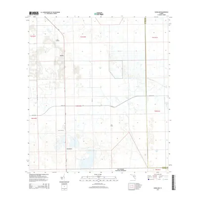
2015 Map of Sunniland
USGS Topo · Published 2015About this map
Sunniland and Harker anchor this portion of the Florida interior, where the managed grid of agricultural development meets the native terrain of the western Everglades. The map illustrates a distinctive landscape of human engineering and natural hydrology, defined by the extensive canal and drainage networks that surround Roberts Lake. Along the southern boundary, the transition into the Big Cypress National Preserve is marked by a shift toward more fragmented wetland features like Sick Island and Owl Hammock. The prevalence of infrastructure labels such as Oil Well Rd and Oil Well Park Rd points to the region's history with the local oil industry, providing a clear record of the access routes used to navigate this low-lying territory in the mid-2010s.
Find a feature on this map
21 named features on this map. Tap any name to fly to it.
Don’t see what you’re looking for? This feature index may not catch every label — zoom into the map to look around manually.
Map Details
Editions of this 2015 Sunniland Map
This is the sole edition of this map. No revisions or reprints were ever made.
Other maps of this area

1956 · West Palm Beach
USGS Topo · 1:250,000

1957 · West Palm Beach
USGS Topo · 1:250,000

1958 · West Palm Beach
USGS Topo · 1:250,000

1958 · Catherine Island
USGS Topo · 1:24,000

1958 · Immokalee
USGS Topo · 1:24,000

1958 · Sunniland
USGS Topo · 1:24,000

1958 · Immokalee NE
USGS Topo · 1:24,000

1958 · Immokalee SW
USGS Topo · 1:24,000

1959 · Miles City
USGS Topo · 1:24,000
1962 · Catherine Island
USGS Topo · 1:24,000