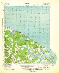
1944 Map of Sunnybank
USGS Topo · Published 1944About this map
Smith Point Light stands as a sentinel at the confluence where the Potomac River meets the Chesapeake Bay, anchoring a landscape defined by the intricate finger-like peninsulas of the Northern Neck. In this mid-century period, the area is a network of small landing points and rural crossroads like Burgess Store, Walkers Store, and Jetts Store. The maritime character of the region is evident in the numerous coves and creeks, such as Cod Creek and Elyson Creek, which carve into landforms like Hack Neck and Hull Neck. Community life centers around local institutions, including Fairfields Ch and its accompanying Fairfields Ch Cem, along with several small schoolhouses like Hygeia School and Grays School. The survey captures a transition point in coastal Virginia, showing the proximity of recreational beaches like Virmare Beach and Ginny Beach to established agricultural and fishing settlements.
Find a feature on this map
52 named features on this map. Tap any name to fly to it.
Don’t see what you’re looking for? This feature index may not catch every label — zoom into the map to look around manually.
Map Details
Editions of this 1944 Sunnybank Map
This is the sole edition of this map. No revisions or reprints were ever made.
Other maps of this area

1894 · Point Lookout
USGS Topo · 1:62,500

1898 · St. Marys
USGS Topo · 1:125,000

1903 · Bloodsworth Island
USGS Topo · 1:62,500

1906 · St. Marys
USGS Topo · 1:125,000

1912 · Point Lookout
USGS Topo · 1:62,500

1917 · Heathsville
USGS Topo · 1:48,000

1917 · Ewell
USGS Topo · 1:62,500

1937 · Point Lookout
USGS Topo · 1:62,500
1942 · Point Lookout
USGS Topo · 1:24,000
1942 · St. George Island
USGS Topo · 1:24,000