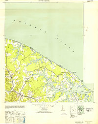
1953 Map of Sunnybank
USGS Topo · Published 1953About this map
The Potomac River dominates the northern reaches of this coastal Virginia landscape, where it meets the Chesapeake Bay at Smith Point. In the mid-20th century, this corner of Northumberland County remained a network of peninsulas defined by deep inlets like the Little Wicomico River. The interior is dotted with the landmarks of a rural Tidewater economy, notably a concentration of local mercantile hubs such as Burgess Store, Walkers Store, and Jetts Store.
Find a feature on this map
51 named features on this map. Tap any name to fly to it.
Don’t see what you’re looking for? This feature index may not catch every label — zoom into the map to look around manually.
Map Details
Editions of this 1953 Sunnybank Map
This is the sole edition of this map. No revisions or reprints were ever made.
Other maps of this area

1894 · Point Lookout
USGS Topo · 1:62,500

1898 · St. Marys
USGS Topo · 1:125,000

1903 · Bloodsworth Island
USGS Topo · 1:62,500

1906 · St. Marys
USGS Topo · 1:125,000

1912 · Point Lookout
USGS Topo · 1:62,500

1917 · Heathsville
USGS Topo · 1:48,000

1917 · Ewell
USGS Topo · 1:62,500

1937 · Point Lookout
USGS Topo · 1:62,500
1942 · Point Lookout
USGS Topo · 1:24,000
1942 · St. George Island
USGS Topo · 1:24,000