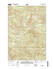
2017 Map of Sunset Spring
USGS Topo · Published 2017About this map
Sunset Spring is located near the intersection of various timber-access routes and logging grades that crisscross the steep drainages along the Clatsop and Tillamook county line. This landscape is defined by its complex network of industrial forest roads, such as the Rock Creek Mainline and Ginger Creek Mainline, which follow the contours of the high ridges and deep creek valleys. Significant terrain markers like Dog Thief Point and Green Mtn rise above a dense drainage system that feeds into the Salmonberry River and the N Fork Salmonberry River. The presence of labels like Eastside Grade and Sterling Ranch Rd suggests the historical and ongoing importance of the timber industry and rural land management in this portion of the Northern Oregon Coast Range.
Find a feature on this map
42 named features on this map. Tap any name to fly to it.
Don’t see what you’re looking for? This feature index may not catch every label — zoom into the map to look around manually.
Map Details
Editions of this 2017 Sunset Spring Map
This is the sole edition of this map. No revisions or reprints were ever made.
Other maps of this area

1937 · Enright
USGS Topo · 1:62,500

1939 · Saddle Mountain
USGS Topo · 1:62,500

1941 · Keasey
USGS Topo · 1:62,500

1941 · Timber
USGS Topo · 1:62,500

1941 · Enright
USGS Topo · 1:62,500

1943 · Keasey
USGS Topo · 1:62,500

1943 · Saddle Mtn.
USGS Topo · 1:62,500

1948 · Vancouver
USGS Topo · 1:250,000

1950 · Vancouver
USGS Topo · 1:250,000

1950 · Vancouver
USGS Topo · 1:250,000