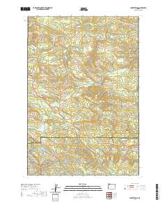
2020 Map of Sunset Spring
USGS Topo · Published 2020About this map
Sunset Spring marks a focal point in the remote upper reaches of the northern Coast Range, where the drainage divides of Clatsop County and Tillamook County meet. This 2020 landscape is defined by an intricate network of industrial forestry roads, including the Rock Creek Mainline, Ginger Creek Mainline, and Quartz Creek Mainline. These routes follow the steep topography carved by the N Fork Salmonberry River and the many forks of Rock Creek. High points like Dog Thief Point and Green Mountain offer vantage points over a terrain dominated by timber management and watershed protection. The presence of the Eastside Grade and Sterling Ranch Rd suggests the continued importance of land access in this heavily timbered region, providing a modern look at the evolving infrastructure of the Oregon backcountry.
Find a feature on this map
42 named features on this map. Tap any name to fly to it.
Don’t see what you’re looking for? This feature index may not catch every label — zoom into the map to look around manually.
Map Details
Editions of this 2020 Sunset Spring Map
This is the sole edition of this map. No revisions or reprints were ever made.
Other maps of this area

1937 · Enright
USGS Topo · 1:62,500

1939 · Saddle Mountain
USGS Topo · 1:62,500

1941 · Keasey
USGS Topo · 1:62,500

1941 · Timber
USGS Topo · 1:62,500

1941 · Enright
USGS Topo · 1:62,500

1943 · Keasey
USGS Topo · 1:62,500

1943 · Saddle Mtn.
USGS Topo · 1:62,500

1948 · Vancouver
USGS Topo · 1:250,000

1950 · Vancouver
USGS Topo · 1:250,000

1950 · Vancouver
USGS Topo · 1:250,000