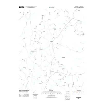
2013 Map of Sunshine
USGS Topo · Published 2013About this map
Sunshine and Washburn anchor this upland Rutherford County landscape, where the foothills rise into prominent summits like Cherry Mountain and Lookadoo Mountain. The community structure is defined by a network of winding mountain roads and several rural sanctuaries, including Sandy Level Church and Mount Lebanon Church. The drainage pattern is particularly dense here, with numerous creeks such as Hunting Cr and Roberson Cr carving through the terrain before reaching the Second Broad River in the southwest. A notable landmark for aviation history is Clute's Hilltop Airport, situated near the center of the quadrangle. This 2013 survey illustrates a modern transition of land use, where traditional Appalachian settlements are increasingly connected by a complex web of named residential roads like Big Rock Dr and Girl Scout Camp Rd, reflecting the area's development while preserving its topographical character.
Find a feature on this map
150 named features on this map. Tap any name to fly to it.
Don’t see what you’re looking for? This feature index may not catch every label — zoom into the map to look around manually.
Map Details
Editions of this 2013 Sunshine Map
This is the sole edition of this map. No revisions or reprints were ever made.
Other maps of this area

1905 · Morganton
USGS Topo · 1:125,000

1950 · Shelby
USGS Topo · 1:62,500

1953 · Charlotte
USGS Topo · 1:250,000

1954 · Charlotte
USGS Topo · 1:250,000

1956 · Benn Knob
USGS Topo · 1:24,000

1960 · Charlotte
USGS Topo · 1:250,000

1962 · Charlotte
USGS Topo · 1:250,000
1962 · Glenwood
USGS Topo · 1:24,000
1962 · Dysartsville
USGS Topo · 1:24,000
1965 · Sunshine
USGS Topo · 1:24,000