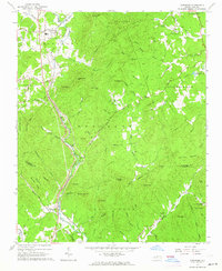
1962 Map of Glenwood
USGS Topo · Published 1964About this map
Glenwood and the southern foothills of the Blue Ridge appear here as they were in the early 1960s, a landscape defined by sharp elevation changes and a dense network of mountain streams. The Clinchfield and Southern railroads parallel the Broad River and the Second Broad River through the valley floors, connecting small communities like Fero and Thermal City. The terrain is punctuated by significant heights such as Higgins Mountain and Huntsmans Mountain, with a Lookout Tower positioned at a high vantage point for forest observation.
Find a feature on this map
93 named features on this map. Tap any name to fly to it.
Don’t see what you’re looking for? This feature index may not catch every label — zoom into the map to look around manually.
Map Details
Editions of this 1962 Glenwood Map
This is the sole edition of this map. No revisions or reprints were ever made.
Other maps of this area

1900 · Mount Mitchell
USGS Topo · 1:125,000

1902 · Mount Mitchell
USGS Topo · 1:125,000

1905 · Morganton
USGS Topo · 1:125,000

1907 · Saluda
USGS Topo · 1:125,000

1953 · Charlotte
USGS Topo · 1:250,000

1954 · Charlotte
USGS Topo · 1:250,000

1955 · Knoxville
USGS Topo · 1:250,000

1957 · Knoxville
USGS Topo · 1:250,000
1959 · Lake Lure
USGS Topo · 1:62,500

1960 · Knoxville
USGS Topo · 1:250,000