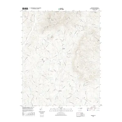
2016 Map of Sunshine
USGS Topo · Published 2016About this map
Sunshine and Washburn anchor the residential landscape of northeastern Rutherford County, where the foothills transition into the South Mountains. This topography is defined by prominent peaks including Cherry Mtn, Joshua Mtn, and Lookadoo Mtn, which split the drainage between several smaller waterways like Hunting Cr and Roberson Cr. The presence of the Second Broad River in the southwest corner and Duncans Cr to the northeast highlights the area's watershed importance.
Find a feature on this map
134 named features on this map. Tap any name to fly to it.
Don’t see what you’re looking for? This feature index may not catch every label — zoom into the map to look around manually.
Map Details
Editions of this 2016 Sunshine Map
This is the sole edition of this map. No revisions or reprints were ever made.
Other maps of this area

1905 · Morganton
USGS Topo · 1:125,000

1950 · Shelby
USGS Topo · 1:62,500

1953 · Charlotte
USGS Topo · 1:250,000

1954 · Charlotte
USGS Topo · 1:250,000

1956 · Benn Knob
USGS Topo · 1:24,000

1960 · Charlotte
USGS Topo · 1:250,000

1962 · Charlotte
USGS Topo · 1:250,000
1962 · Glenwood
USGS Topo · 1:24,000
1962 · Dysartsville
USGS Topo · 1:24,000
1965 · Sunshine
USGS Topo · 1:24,000