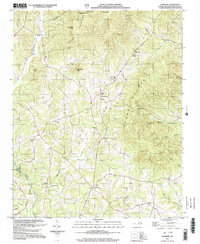
2002 Map of Sunshine
USGS Topo · Published 2003About this map
South Mountains and Cherry Mountain dominate this landscape in Rutherford County, defining a rugged geography where small communities like Sunshine and Washburn are tucked into the valleys. The map reveals a dense network of local landmarks essential for genealogical research, particularly its numerous rural congregations and burial grounds such as Mt Harmony Ch, Cedar Grove Ch, and the Sunshine Cem. These sites, often situated near watercourses like Hunting Creek and Roberson Creek, reflect a settlement pattern deeply tied to the natural drainage of the Second Broad River.
Find a feature on this map
44 named features on this map. Tap any name to fly to it.
Don’t see what you’re looking for? This feature index may not catch every label — zoom into the map to look around manually.
Map Details
Editions of this 2002 Sunshine Map
This is the sole edition of this map. No revisions or reprints were ever made.
Other maps of this area

1905 · Morganton
USGS Topo · 1:125,000

1950 · Shelby
USGS Topo · 1:62,500

1953 · Charlotte
USGS Topo · 1:250,000

1954 · Charlotte
USGS Topo · 1:250,000

1956 · Benn Knob
USGS Topo · 1:24,000

1960 · Charlotte
USGS Topo · 1:250,000

1962 · Charlotte
USGS Topo · 1:250,000
1962 · Glenwood
USGS Topo · 1:24,000
1962 · Dysartsville
USGS Topo · 1:24,000
1965 · Sunshine
USGS Topo · 1:24,000