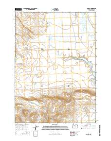
2014 Map of Suntex
USGS Topo · Published 2014About this map
Suntex serves as the focal point of this high-desert landscape in Harney County, where the management of water defines the patterns of settlement and transport. The Chickahominy Reservoir sits as a significant feature on the landscape, fed by the waters of Chickahominy Cr as it flows toward the junction of Us-20. The infrastructure of the area is highlighted by local access roads like Mayo Ranch Ln and Silver Creek Rd, which provide access to remote ranching properties and the riparian corridors of Silver Cr. In the western portion of the quadrangle, Sheep Lake and the engineered Sheep L Ditch illustrate the historical efforts to divert and utilize seasonal water in an arid environment. The map details the transition from the flat drainage basins to the higher elevations reached via Placidea Butte Rd in the south.
Find a feature on this map
17 named features on this map. Tap any name to fly to it.
Don’t see what you’re looking for? This feature index may not catch every label — zoom into the map to look around manually.
Map Details
Editions of this 2014 Suntex Map
This is the sole edition of this map. No revisions or reprints were ever made.
Other maps of this area

1955 · Burns
USGS Topo · 1:250,000

1958 · Burns
USGS Topo · 1:250,000

1959 · Burns
USGS Topo · 1:250,000

1980 · Capehart Lake
USGS Topo · 1:24,000

1980 · Squaw Butte
USGS Topo · 1:24,000

1980 · Hay Lake
USGS Topo · 1:24,000
1981 · Potato Hills
USGS Topo · 1:24,000
1981 · Bulger Ridge
USGS Topo · 1:24,000

1981 · Camp Currey Spring
USGS Topo · 1:24,000
1981 · Suntex
USGS Topo · 1:24,000