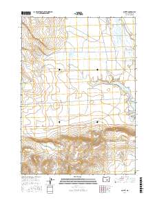
2017 Map of Suntex
USGS Topo · Published 2017About this map
The high desert landscape of Harney County is defined by the ephemeral water systems and sparse ranching outposts surrounding Suntex. This 2017 survey documents the critical water management features of the area, including the Chickahominy Reservoir and the drainage network of the N Fork Chickahominy Cr, S Fork Chickahominy Cr, and the main Chickahominy Cr. These water sources are vital for the agricultural operations that rely on local infrastructure such as the Sheep L Ditch and the proximity of Sheep Lake. The map reveals the layout of isolated ranch roads and service lanes like Mayo Ranch Ln and Best Ln, which connect the spread-out homesteads across the sagebrush-covered plains and volcanic features. To the south, topographic relief increases near Squaw Butte Rd and Placidia Butte Rd, marking the transition into more broken rangeland.
Find a feature on this map
18 named features on this map. Tap any name to fly to it.
Don’t see what you’re looking for? This feature index may not catch every label — zoom into the map to look around manually.
Map Details
Editions of this 2017 Suntex Map
This is the sole edition of this map. No revisions or reprints were ever made.
Other maps of this area

1955 · Burns
USGS Topo · 1:250,000

1958 · Burns
USGS Topo · 1:250,000

1959 · Burns
USGS Topo · 1:250,000

1980 · Capehart Lake
USGS Topo · 1:24,000

1980 · Squaw Butte
USGS Topo · 1:24,000

1980 · Hay Lake
USGS Topo · 1:24,000
1981 · Potato Hills
USGS Topo · 1:24,000
1981 · Bulger Ridge
USGS Topo · 1:24,000

1981 · Camp Currey Spring
USGS Topo · 1:24,000
1981 · Suntex
USGS Topo · 1:24,000