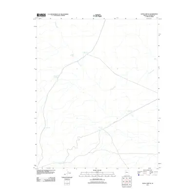
2011 Map of Supai Camp SE
USGS Topo · Published 2011About this map
Sandstone Wash defines the hydrological character of this high desert terrain in Coconino County, carving through a landscape primarily marked by an essential network of water management features. At the time of this 2011 survey, the area serves as a critical infrastructure corridor, highlighted by the diagonal transit of the Aqueduct. The reliance on local water catchment is evident in the numbered distribution of reservoirs such as Water Tank Number One and One-Half, Water Tank Number Seven, and Water Tank Number Eight. These features, alongside isolated points like Midway Tank, illustrate the systematic approach to sustaining livestock or managing resources in a region where surface water is seasonal and scarce. The map reveals a land structured around the movement of water and the maintenance of modern utility routes.
Find a feature on this map
10 named features on this map. Tap any name to fly to it.
Don’t see what you’re looking for? This feature index may not catch every label — zoom into the map to look around manually.
Map Details
Editions of this 2011 Supai Camp SE Map
This is the sole edition of this map. No revisions or reprints were ever made.
Other maps of this area

1886 · Chino
USGS Topo · 1:250,000

1891 · Chino
USGS Topo · 1:250,000

1948 · Williams
USGS Topo · 1:250,000

1954 · Williams
USGS Topo · 1:250,000

1956 · Williams
USGS Topo · 1:250,000

1960 · Williams
USGS Topo · 1:250,000

1961 · Williams
USGS Topo · 1:250,000
1980 · Rose Well Camp West
USGS Topo · 1:24,000

1980 · Hazen Hole Tank
USGS Topo · 1:24,000
1980 · Black Tank
USGS Topo · 1:24,000