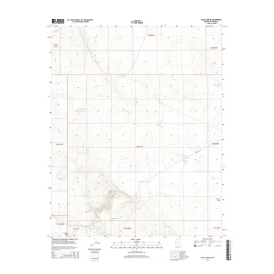
2014 Map of Supai Camp SE
USGS Topo · Published 2014About this map
Sandstone Wash defines the drainage patterns of this high-altitude Coconino County landscape, where the management of water is the primary human imprint. The terrain is characterized by a series of numbered catchments and infrastructure including Water Tank Number Eight, Water Tank Number Six, and the prominent Midway Tank located in the northeastern section. These features, along with Lower Sandstone Tank, underscore the necessity of water storage in this arid environment. The presence of Acqueduct Rd cutting through the central and southern portions of the survey area indicates modern utility corridors that follow the natural contours of the land. In the southern reaches, Rodgers Draw provides a distinct topographic break, serving as a landmark for those navigating the transition between the various township ranges.
Find a feature on this map
21 named features on this map. Tap any name to fly to it.
Don’t see what you’re looking for? This feature index may not catch every label — zoom into the map to look around manually.
Map Details
Editions of this 2014 Supai Camp SE Map
This is the sole edition of this map. No revisions or reprints were ever made.
Other maps of this area

1886 · Chino
USGS Topo · 1:250,000

1891 · Chino
USGS Topo · 1:250,000

1948 · Williams
USGS Topo · 1:250,000

1954 · Williams
USGS Topo · 1:250,000

1956 · Williams
USGS Topo · 1:250,000

1960 · Williams
USGS Topo · 1:250,000

1961 · Williams
USGS Topo · 1:250,000
1980 · Rose Well Camp West
USGS Topo · 1:24,000

1980 · Hazen Hole Tank
USGS Topo · 1:24,000
1980 · Black Tank
USGS Topo · 1:24,000