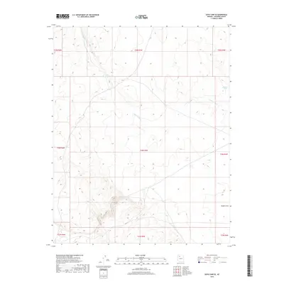
2018 Map of Supai Camp SE
USGS Topo · Published 2018About this map
Sandstone Wash defines the drainage patterns of this high-altitude landscape in Coconino County, cutting through the vast townships of the Kaibab Plateau region. This 2018 survey documents a sparse, arid environment where water management is centralized around features like Lower Sandstone Tank and Midway Tank, which serve as vital collectors in an otherwise dry terrain. To the southeast, the land transitions into Rodgers Draw, illustrating the complex natural irrigation and erosion channels that shape this corner of the Arizona wilderness. The map provides a clear look at the Public Land Survey System grid across T28N and T29N, offering a precise view of the geographic divisions in this section of the state.
Find a feature on this map
13 named features on this map. Tap any name to fly to it.
Don’t see what you’re looking for? This feature index may not catch every label — zoom into the map to look around manually.
Map Details
Editions of this 2018 Supai Camp SE Map
This is the sole edition of this map. No revisions or reprints were ever made.
Other maps of this area

1886 · Chino
USGS Topo · 1:250,000

1891 · Chino
USGS Topo · 1:250,000

1948 · Williams
USGS Topo · 1:250,000

1954 · Williams
USGS Topo · 1:250,000

1956 · Williams
USGS Topo · 1:250,000

1960 · Williams
USGS Topo · 1:250,000

1961 · Williams
USGS Topo · 1:250,000
1980 · Rose Well Camp West
USGS Topo · 1:24,000

1980 · Hazen Hole Tank
USGS Topo · 1:24,000
1980 · Black Tank
USGS Topo · 1:24,000