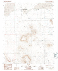
1988 Map of Superior Lake
USGS Topo · Published 1988About this map
Superior Valley dominates this high desert landscape, characterized by a significant (Depression) that contains the ephemeral Superior Lake. Surveyed in the late 1980s, the terrain is defined by prominent elevations such as the flat-topped Mesa and the peak known as Spear. The map reveals a history of water-seeking in this arid environment, evidenced by several water sources now marked as inactive, including Coutts Well, East Well, and Murphys Well. Evidence of exploration and resource hunting is scattered throughout the region, with several sites simply labeled Prospect or Prospects indicating past mineral interest. The area remains sparsely developed, with a network of unimproved roads and trails providing the only access through the desert floor and up toward the northern mountains.
Find a feature on this map
15 named features on this map. Tap any name to fly to it.
Don’t see what you’re looking for? This feature index may not catch every label — zoom into the map to look around manually.
Map Details
Editions of this 1988 Superior Lake Map
This is the sole edition of this map. No revisions or reprints were ever made.
Other maps of this area

1915 · Searles Lake
USGS Topo · 1:250,000

1933 · Avawatz Mountains
USGS Topo · 1:250,000

1947 · Trona
USGS Topo · 1:250,000

1948 · Trona
USGS Topo · 1:250,000

1948 · Lane Mountain
USGS Topo · 1:62,500

1948 · Goldstone Lake
USGS Topo · 1:62,500

1951 · Goldstone Lake
USGS Topo · 1:62,500

1951 · Lane Mountain
USGS Topo · 1:62,500

1953 · Trona
USGS Topo · 1:250,000

1954 · Pilot Knob
USGS Topo · 1:62,500