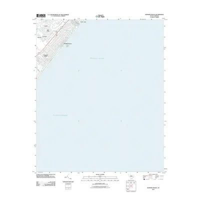
2011 Map of Surfside Beach
USGS Topo · Published 2011About this map
Surfside Beach serves as the focal point of this coastal survey, illustrating the dense residential grid and recreational infrastructure that characterizes this portion of the Grand Strand. The shoreline is punctuated by the Surfside Fishing Pier, a prominent local landmark extending into the Atlantic Ocean. Inland, the map details a series of planned communities and developments including Oceanside Village, Surf Pines, and Longleaf, which are woven between small freshwater bodies such as Dogwood Lake and Floral Lake. The presence of the Ocean Lakes Family Campground to the north reflects the area's established identity as a destination for seasonal visitors. For those researching local development or property history, the map provides a precise layout of the street network, from N Waccamaw Dr along the beachfront to the many residential loops and lanes like Circle Dr and Sandy Ln.
Find a feature on this map
24 named features on this map. Tap any name to fly to it.
Don’t see what you’re looking for? This feature index may not catch every label — zoom into the map to look around manually.
Map Details
Editions of this 2011 Surfside Beach Map
This is the sole edition of this map. No revisions or reprints were ever made.
Other maps of this area

1937 · Myrtle Beach
USGS Topo · 1:48,000

1940 · Myrtle Beach
USGS Topo · 1:62,500

1942 · Magnolia Beach
USGS Topo · 1:24,000

1943 · Bucksville
USGS Topo · 1:24,000

1943 · Brookgreen
USGS Topo · 1:24,000

1949 · Georgetown
USGS Topo · 1:250,000

1967 · Georgetown
USGS Topo · 1:250,000

1974 · Georgetown
USGS Topo · 1:250,000
1984 · Ocean Forest
USGS Topo · 1:24,000
1984 · Myrtle Beach
USGS Topo · 1:24,000