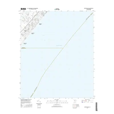
2017 Map of Surfside Beach
USGS Topo · Published 2017About this map
Surfside Beach and the neighboring coastal communities of Garden City and Garden City Beach occupy a thin, developed strip of the South Carolina coast along Long Bay. This survey illustrates the dense residential street grids and seaside neighborhoods just before the county line into Georgetown County. In contrast to the developed shoreline, inland features like Big Swamp suggest the low-lying wetlands that historically defined the terrain behind the beach. Notable local landmarks include Dogwood Lake, Floral Lake, and Oceanside Village, which sit adjacent to primary local thoroughfares such as Glenns Bay Rd and Platt Blvd. The map provides a detailed look at the 21st-century footprint of these resort communities and their relationship with the Atlantic Ocean.
Find a feature on this map
77 named features on this map. Tap any name to fly to it.
Don’t see what you’re looking for? This feature index may not catch every label — zoom into the map to look around manually.
Map Details
Editions of this 2017 Surfside Beach Map
This is the sole edition of this map. No revisions or reprints were ever made.
Other maps of this area

1937 · Myrtle Beach
USGS Topo · 1:48,000

1940 · Myrtle Beach
USGS Topo · 1:62,500

1942 · Magnolia Beach
USGS Topo · 1:24,000

1943 · Bucksville
USGS Topo · 1:24,000

1943 · Brookgreen
USGS Topo · 1:24,000

1949 · Georgetown
USGS Topo · 1:250,000

1967 · Georgetown
USGS Topo · 1:250,000

1974 · Georgetown
USGS Topo · 1:250,000
1984 · Ocean Forest
USGS Topo · 1:24,000
1984 · Myrtle Beach
USGS Topo · 1:24,000