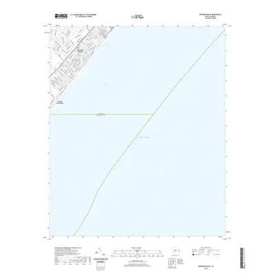
2020 Map of Surfside Beach
USGS Topo · Published 2020About this map
Surfside Beach and Garden City Beach occupy the coastal strip of the Grand Strand in this 2020 record, showing a landscape defined by residential development and leisure tourism. The map captures the dense street grid of the beach communities, where roads like Glenns Bay Rd and Platt Blvd lead toward the shore of Long Bay. Inland of the dunes, local hydrology is marked by Dogwood Lake and Floral Lake, providing a contrast to the expanse of the Atlantic Ocean.
Find a feature on this map
80 named features on this map. Tap any name to fly to it.
Don’t see what you’re looking for? This feature index may not catch every label — zoom into the map to look around manually.
Map Details
Editions of this 2020 Surfside Beach Map
This is the sole edition of this map. No revisions or reprints were ever made.
Other maps of this area

1937 · Myrtle Beach
USGS Topo · 1:48,000

1940 · Myrtle Beach
USGS Topo · 1:62,500

1942 · Magnolia Beach
USGS Topo · 1:24,000

1943 · Bucksville
USGS Topo · 1:24,000

1943 · Brookgreen
USGS Topo · 1:24,000

1949 · Georgetown
USGS Topo · 1:250,000

1967 · Georgetown
USGS Topo · 1:250,000

1974 · Georgetown
USGS Topo · 1:250,000
1984 · Ocean Forest
USGS Topo · 1:24,000
1984 · Myrtle Beach
USGS Topo · 1:24,000